---
title: Data editing and management system (SaaS)
source_url: "https://architecture.arcgis.com/en/framework/system-patterns/data-editing-and-management/deployment-patterns/as-saas.html"
md_url: "https://architecture.arcgis.com/en/framework/system-patterns/data-editing-and-management/deployment-patterns/as-saas.md"
---
# Data editing and management system (SaaS)
The data editing and management system pattern is available as a software as a service (SaaS) based deployment using ArcGIS Online.
[ArcGIS Online](https://www.esri.com/en-us/arcgis/products/arcgis-online/overview) is a cloud-based GIS managed and delivered as SaaS by Esri. ArcGIS Online provides capabilities that span the data, services/logic, and presentation tiers, working together to provide a complete system. Built on world-class cloud architecture and managed by IT and geographic information system (GIS) experts, ArcGIS Online offers reliable and comprehensive web-based GIS capabilities.
Related resources:
- [ArcGIS Online Resources](https://www.esri.com/en-us/arcgis/products/arcgis-online/resources)
- [ArcGIS Online Trial](https://www.esri.com/en-us/arcgis/products/arcgis-online/trial)
# Base architecture
The following is a [typical base architecture](/en/framework/system-patterns/anatomy-of-a-system-pattern.md#base-architecture) for a data editing and management system deployed as SaaS.
This diagram should not be taken as is and used as the design for your system. There are many important factors and design choices that should be considered when designing your system. Review the [using system patterns](/en/framework/system-patterns/using-system-patterns.md) topic for more information. Additionally, the diagram depicted below delivers only the base capabilities of the system; additional system components may be required when delivering extended capabilities.
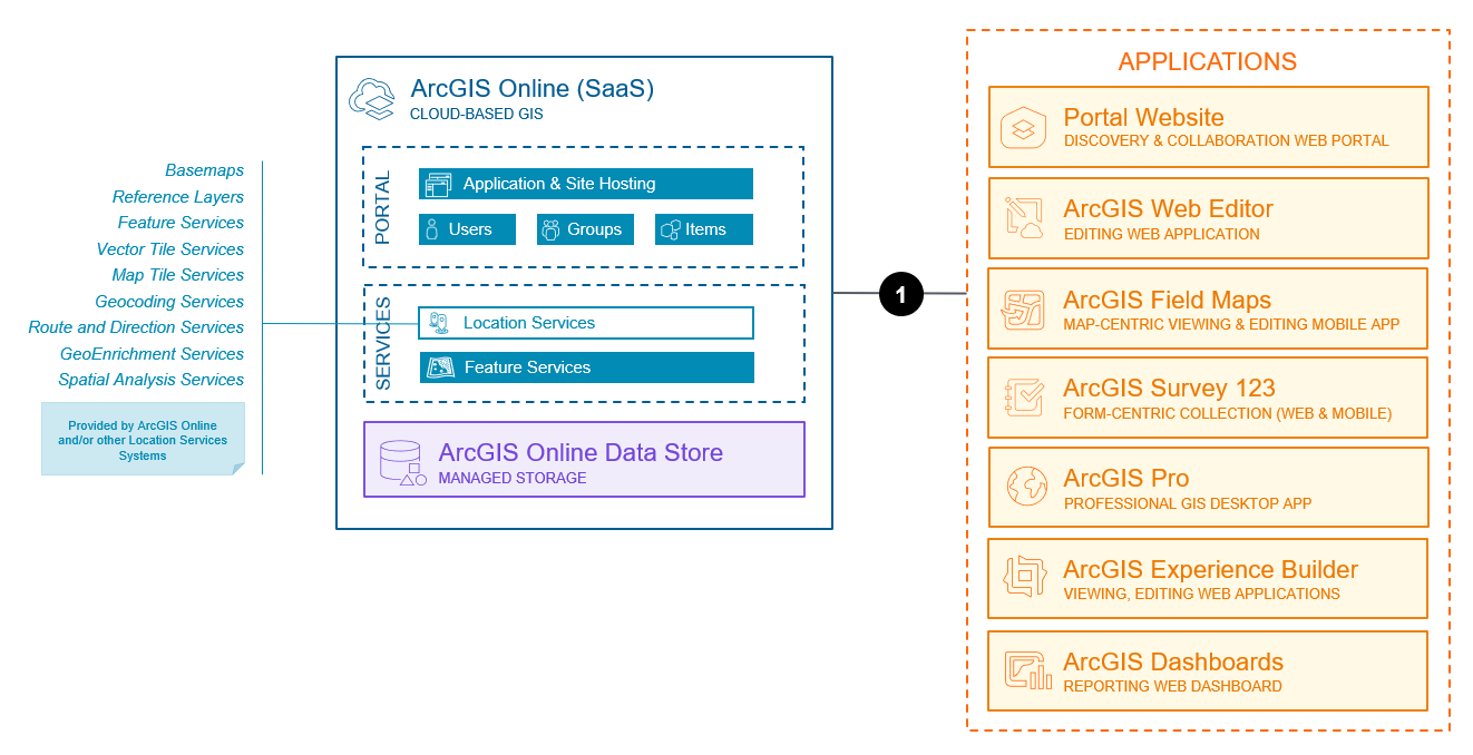
_The capabilities represented above reflect those available as of July, 2026._
Key components of this architecture include:
- ArcGIS Online, including standard portal components such as users, groups, and items, as well as location services such as basemaps and geocoding services. The location services powering the data editing and management system may also come in part or full from another [location services system](/en/framework/system-patterns/location-services/overview.md).
- Editing capabilities are provided by ArcGIS Online [hosted feature services](https://doc.arcgis.com/en/arcgis-online/reference/feature-layers.htm#ESRI_SECTION1_26EBAE21F63042B9A51A4312A08A1B25). The data being edited is also stored within ArcGIS Online, in cloud-based storage managed by Esri. Data can also be [published](https://doc.arcgis.com/en/arcgis-online/manage-data/publish-features.htm) to ArcGIS Online from several sources.
- There are several applications commonly used in this pattern. Learn more about [applications](/en/framework/system-patterns/data-editing-and-management/overview.md#applications) used in data editing and management systems.
> [!NOTE]
> **Note**
> Hosting for custom, full-code web applications is not provided by ArcGIS Online. External web hosting (e.g., web server), not depicted in the diagram above, is required for hosting custom, full-code web applications.
Key interactions in this architecture include:
1. Client applications communicate with data services as well as location services over HTTPS, typically via stateless REST APIs. This pattern makes heavy use of [feature services](https://doc.arcgis.com/en/arcgis-online/reference/feature-layers.htm#ESRI_SECTION1_26EBAE21F63042B9A51A4312A08A1B25) for editing specifically, though several other service types are typically be used as well.
Additional information on using and administering ArcGIS Online can be found in the ArcGIS Online [product documentation](https://doc.arcgis.com/en/arcgis-online/get-started/what-is-agol.htm).
# Capabilities
The capabilities of the data editing and management system on SaaS are described below. See the [capability overview](/en/framework/system-patterns/data-editing-and-management/overview.md#capabilities) and [comparison of capability support](/en/framework/system-patterns/data-editing-and-management/selecting-a-deployment-pattern.md#capability-comparison) across deployment patterns for more information.
Capabilities used in a data editing and management system, but typically provided by other systems, such as basemaps, geocoding, and other location services provided by a [location services system](/en/framework/system-patterns/location-services/overview.md) are not listed below. Learn more about [related system patterns](/en/framework/system-patterns/data-editing-and-management/overview.md#related-system-patterns).
### Base capabilities
Base capabilities represent the most common capabilities delivered by data editing and management systems and that are enabled by the [base architecture](#base-architecture) presented above.
- [Mapping and visualization](/en/framework/system-patterns/data-editing-and-management/overview.md#mapping-visualization) enable you to visualize and map your data before, during, and after editing by [making maps](https://www.esri.com/en-us/arcgis/products/arcgis-online/capabilities/make-maps) as well as [geoenabling and hosting your data](https://www.esri.com/en-us/arcgis/products/arcgis-online/capabilities/data).
- [Data editing](/en/framework/system-patterns/data-editing-and-management/overview.md#data-editing) in the SaaS deployment pattern is provided by the service-based [data access and editing](https://doc.arcgis.com/en/arcgis-online/manage-data/data-access-and-editing.htm) features of ArcGIS Online. This includes editing of geometry and attributes.
- [Data import and export](/en/framework/system-patterns/data-editing-and-management/overview.md#data-import-export) in bulk is supported through the [import and export features](https://doc.arcgis.com/en/arcgis-online/manage-data/manage-hosted-feature-layers.htm) of feature services hosted in ArcGIS Online. [Data Pipelines](https://doc.arcgis.com/en/data-pipelines/latest/get-started/about-data-pipelines.htm) can also be used to import data into ArcGIS Online.
- [Edit tracking and auditing](/en/framework/system-patterns/data-editing-and-management/overview.md#tracking-auditing) enables automatic recording of information about any data inserts or updates using [editor tracking](https://doc.arcgis.com/en/arcgis-online/manage-data/manage-editing-hfl.htm#ESRI_SECTION2_60D988F67914496C8D5DC454DF25080D) in ArcGIS Online.
- [Short transaction management](/en/framework/system-patterns/data-editing-and-management/overview.md#short-transcations) enables lock-free, short transaction editing using [feature services](https://doc.arcgis.com/en/arcgis-online/reference/feature-layers.htm#GUID-2F228561-6030-4D1E-9E3A-BCD2CF54F1EF) hosted in ArcGIS Online
- [Data distribution and replication](/en/framework/system-patterns/data-editing-and-management/overview.md#data-distribution) allows for data to be shared and synchronized with other ArcGIS systems using [partnered and distributed collaborations](https://doc.arcgis.com/en/arcgis-online/administer/understand-collaborations.htm).
### Extended capabilities
Extended capabilities are typically added to meet specific needs or support industry specific data models and solutions, and may require additional software components or architectural considerations.
- Increase ArcGIS Online subscription feature data storage and support for intensive query, edit, analysis, and extract with [Premium Feature Data Store](https://www.esri.com/en-us/arcgis/products/premium-feature-data-store/buy) options.
- [Data interoperability and transformation](/en/framework/system-patterns/data-editing-and-management/overview.md#data-interop) capabilities support data movement among hundreds of systems and apps using the visual programming interface provided by [ArcGIS Data Interoperability](https://www.esri.com/en-us/arcgis/products/arcgis-data-interoperability/overview), which includes reading and writing to hosted feature services in ArcGIS Online. An alternative for easily creating and scheduling simple pipelines that write data to ArcGIS Online is [Data Pipelines](https://doc.arcgis.com/en/data-pipelines/latest/get-started/about-data-pipelines.htm).
- [Workflow management and automation](/en/framework/system-patterns/data-editing-and-management/overview.md#workflow-management) extends ArcGIS Online with the capability to orchestrate and automate work across teams using [ArcGIS Workflow Manager](https://www.esri.com/en-us/arcgis/products/arcgis-workflow-manager/deployment/online).
- [Hosted Python notebooks](/en/framework/system-patterns/data-editing-and-management/overview.md#hosted-notebooks) enable Python-based analysis, administration, and automation using [ArcGIS Notebooks](https://www.esri.com/en-us/arcgis/products/arcgis-notebooks/workspace-options/arcgis-online) delivered as SaaS through ArcGIS Online.
- [Indoor GIS](/en/framework/system-patterns/data-editing-and-management/overview.md#indoor-gis) extends the capabilities of ArcGIS Online with ability to create and manage floor plan data, map building interiors, and share floor-aware maps and services. This capability requires [ArcGIS Pro](https://www.esri.com/en-us/arcgis/products/arcgis-pro/overview), and is made possible by [ArcGIS Indoors](https://www.esri.com/en-us/arcgis/products/arcgis-indoors/overview). Indoor GIS also extends the capabilities of ArcGIS Online with indoor space management and workspace reservations using [ArcGIS Indoor Spaces](https://www.esri.com/en-us/arcgis/products/arcgis-indoors/license-levels/spaces), a capability delivered through ArcGIS Indoors.
- [Other industry solutions](/en/framework/system-patterns/data-editing-and-management/overview.md#industry-solutions) allow for rapid deployment of industry-specific apps and configurations of ArcGIS Online using [ArcGIS Solutions](https://www.esri.com/en-us/arcgis/products/arcgis-solutions/overview).
# Considerations
The considerations below apply the pillars of the ArcGIS Well-Architected Framework to the data editing and management system pattern on SaaS. The information presented here is not meant to be exhaustive, but rather highlights key considerations for designing and/or implementing this specific combination of system and deployment pattern. Learn more about the [architecture pillars](/en/framework/architecture-practices/introduction.md#architecture-pillars) of the ArcGIS Well-Architected Framework.
### Reliability
Reliability ensures your system provides the level of service required by the business, as well as your customers and stakeholders. For more information, see the [reliability pillar overview](/en/framework/architecture-pillars/reliability/overview.md).
- ArcGIS Online leverages multiple availability zones, regions, and service providers to ensure redundancy, resiliency, and service continuity.
- [Service Level Agreement (SLA)](https://www.esri.com/content/dam/esrisites/en-us/media/legal/referenced-files/g-632-agol-service-level.pdf) provided by ArcGIS Online.
- Data integrity and recoverability is typically paramount with this type of system, thus backup processes and procedures external to ArcGIS Online are recommended.
### Security
Security protects your systems and information. For more information, see the [security pillar overview](/en/framework/architecture-pillars/security/overview.md).
- [Authentication](/en/framework/architecture-pillars/security/authentication-models-and-providers.md) and [authorization](/en/framework/architecture-pillars/security/authorization-and-access-models.md) are almost always required, apart from a crowd sourcing style collection scenario (though these are more commonly deployed using SaaS or PaaS).
- User access and data collaboration are governed by role-based access controls and modern authorization and authentication models, including OAuth, SAML, and multi-factor authentication.
- Auditing is very common, and is typically implemented using [editor tracking](https://doc.arcgis.com/en/arcgis-online/manage-data/manage-editing-hfl.htm#ESRI_SECTION2_60D988F67914496C8D5DC454DF25080D).
- Systems are subject to vulnerability assessments including system, web application, and database scans.
Learn more about [ArcGIS Online security best practices and implementation guidance](https://trust.arcgis.com/en/security/arcgis-online-guidance.htm).
### Performance & Scalability
Performance and scalability aim to optimize the overall experience users have with the system, as well as ensure the system scales to meet evolving workload demands. For more information, see the [performance and scalability pillar overview](/en/framework/architecture-pillars/performance-and-scalability/overview.md).
- Scaling is handled automatically by ArcGIS Online.
- Multiple content delivery networks deliver highly scalable maps and apps to diverse locations around the world.
- For additional feature data storage support, isolation, and compute, consider the ArcGIS Online [Premium Feature Data Store](https://www.esri.com/en-us/arcgis/products/premium-feature-data-store/buy) extended capability.
- For both performance and data residency, regional geospatial data hosting is available in the United States, Europe, and Asia-Pacific.
### Automation
Automation aims to reduce effort spent on manual deployment and operational tasks, leading to increased operational efficiency as well as reduction in human introduced system anomalies. For more information, see the [automation pillar overview](/en/framework/architecture-pillars/automation/overview.md).
- Workflow automation is increasingly common with SaaS-based data editing and management systems, especially with large groups of editors working in concert to edit and maintain shared or related datasets. Please see [ArcGIS Workflow Manager](https://www.esri.com/en-us/arcgis/products/arcgis-workflow-manager/deployment/online) for more information on this extended capability.
- Data management often involves automation, typically using Python to access and manage data in ArcGIS Online managed data storage. This is most commonly done using the [ArcGIS API for Python](https://developers.arcgis.com/python/) as well as [ArcGIS Notebooks](https://www.esri.com/en-us/arcgis/products/arcgis-notebooks/workspace-options/arcgis-online) delivered as SaaS through ArcGIS Online.
### Integration
Integration connects this system with other systems for delivering enterprise services and amplifying organizational productivity. For more information, see the [integration pillar overview](/en/framework/architecture-pillars/integration/overview.md).
- Integration with other information systems such as Enterprise Asset Management (EAM), Customer Relationship Management (CRM), and Computer-Assisted Mass Appraisal (CAMA) systems is common.
- Data exchange and alignment between systems is very typical
- Use of ArcGIS APIs and SDKs is quite common
- 3rd party integration tools and applications are also available
### Observability
Observability provides visibility into the system, enabling operations staff and other technical roles to keep the system running in a healthy, steady state. For more information see the [observability pillar overview](/en/framework/architecture-pillars/observability/overview.md)
- Successful operation of data editing and management systems typically benefits from a good understanding of how data is being edited and by whom. This may include, but is not limited to, who is editing what, the nature of those edits, the nature of edit transactions, use of batch editing capabilities, as well as the overall volume and cadence of edits. Management and monitoring of feature services is especially important, including use of [edit tracking and auditing](#tracking-auditing).
- [Feature service webhooks](https://www.esri.com/arcgis-blog/products/arcgis-online/sharing-collaboration/how-to-create-a-hosted-feature-service-webhook/) can also be employed for observability purposes.
- ArcGIS Online, as a SaaS offering, does not support observation of its underlying infrastructure and software internals. It does, however, offer ways to observe system utilization and health.
- Monitor the health and availability of ArcGIS Online services and key components at the [ArcGIS Online Health Dashboard](https://status.arcgis.com/), as well as ArcGIS Living Atlas of the World [live feed status](https://livingatlas.arcgis.com/livefeeds-status/).
- [View and report on usage status](https://doc.arcgis.com/en/arcgis-online/administer/view-status.htm) of an ArcGIS Online subscription, including organization's credit usage, member status and activity, content usage, apps, and groups. Also consider [monitoring usage of specific items](https://doc.arcgis.com/en/arcgis-online/manage-data/monitor-item-usage.htm), including maps, layers, and other content published through the location services system. Learn more about [best practices for organization maintenance](https://doc.arcgis.com/en/arcgis-online/reference/best-practices-maintenance.htm) in ArcGIS Online.
- Some extended capabilities of this system pattern, such as workflow management and automation with ArcGIS Workflow Manager, have additional observability support. Review the corresponding product documentation for more information.
- Use of [web analytics](/en/framework/architecture-pillars/observability/define-and-capture-telemetry.md#web-analytics) may also be helpful for editing using custom web-based applications.
- Additional observation of user logins and account changes may be possible through the configured identity provider when using SAML and/or OpenID Connect logins.
### Other
Additional considerations for designing and implementing a data editing and management system as SaaS include:
- Successful operation requires strong understanding of GIS and IT concepts as well as technology. The organization should also understand the implication of SaaS, from a data access, security, and management perspective.
- Data governance and alignment with IT policies and roles, such as data steward and content manager, should strongly be considered when implementing this system pattern.
Related resources:
- [ArcGIS Trust Center](https://trust.arcgis.com/en/)
- [Esri's secure development lifecycle](https://downloads.esri.com/RESOURCES/ENTERPRISEGIS/Esri_SDLC.pdf)
- [Esri's commitment to accessibility](https://www.esri.com/en-us/accessibility/overview)