Introduction
The utility sector is undergoing significant changes driven by resource constraints, infrastructure modernization goals, and a growing need for resilience. As these challenges intensify, utilities must adopt innovative solutions to ensure efficiency, reliability, and sustainability. Technology plays a pivotal role in this transformation, enabling digital transformation that helps utilities optimize operations, improve decision-making, and adapt to an evolving utility sector landscape. At Esri we support utility organizations in delivering safe and reliable resources with mission-focused ArcGIS systems that realize operational excellence while optimizing the use of assets and resources.
ArcGIS enables this transition through scalable solutions designed to meet the needs of both large and small utility organizations. It uses geospatial technology to model, analyze, and manage infrastructure, allowing utilities to effectively adapt and respond to industry challenges while improving service delivery and resource management.
Utilities often achieve significant return on their ArcGIS investment through building and operating mission focused interconnected ArcGIS systems, ensuring business needs and processes are met while leveraging the advantages of an integrated, data-driven approach. Many of these system types are described in detail within the Utility Lens, which aims to inform utilities on system patterns often deployed by utility customers.
- New to ArcGIS? Consider starting with an Introduction to ArcGIS.
ArcGIS for utility organizations
Utilities operate with various business systems to meet diverse requirements, which can be influenced by regulatory, environmental, and sector-specific standards. Geospatial information and context can significantly enhance operational efficiency, regulatory compliance, and safety within these systems. However, ArcGIS is not merely a collection of mapping tools; it is a comprehensive geospatial enterprise platform that enables organizations to design, build, and operate systems tailored to the unique challenges of modern utilities.
Utility organizations typically operate multiple ArcGIS systems; however, the Network information management system can be considered foundational. Network information management systems provide users across the organization with the ability to create, edit, view, and analyze network features and relationships across an as-built network.
ArcGIS systems approach
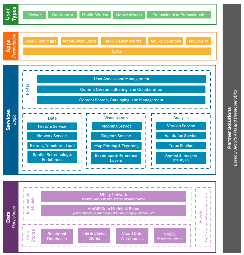
All users authenticate through a portal which provides identity management, content management, and security capabilities. Users access an ArcGIS system with an appropriate User type, which grants them necessary apps and capabilities based on their roles. For example:
- An editor might create and maintain asset information in ArcGIS Pro with a Professional Plus User Type.
- An asset inspector might access and update asset information in ArcGIS Field Maps with a Mobile Worker User Type.
- An operations manager might view assets, issues, and progress in an Operations Dashboard with a Viewer User Type.
This ensures staff receive the right content and capabilities based on their roles. These content and capabilities in turn are powered by several types of ArcGIS services, including:
- Data services, like network topology services to model and validate connectivity
- Mapping and visualization services, like diagram services to create schematics
- Analysis services, like trace services to perform upstream and downstream traces
The services rely on the data tier of ArcGIS, which includes ArcGIS information models like the ArcGIS Utility Network, designed for electric, gas, telecom, and water utilities globally. The utility information is stored in standard databases like SQL Server, Oracle, PostgreSQL, or SAP HANA, and can be integrated with other enterprise business systems like Enterprise Asset Management ( EAM), Supervisory Control and Data Acquisition (SCADA), or Automatic Vehicle Location (AVL.)

Adopting ArcGIS
Utilities have flexibility in determining their own path to ArcGIS adoption to enhance operational efficiencies and adaption to emerging industry requirements.
The following sections will provide insight into architecture and system patterns powered by ArcGIS to help utilities enable their business systems with confidence.
Related resources: