Self-service mapping, analysis, and sharing system
A self-service mapping, analysis, and sharing system is a web-centric, services-based system for self-service creation, sharing, and use of data, maps, and applications. This system pattern empowers individuals and teams to create, share, and use geospatial content without significant technical expertise or GIS knowledge. It also supports self-service spatial analysis. While web-centric, users may interact with it using not only web applications, but also mobile applications and ArcGIS Pro, a desktop application. This pattern is often how ArcGIS is introduced to an organization and can serve as both an engagement center and a creative engine for the enterprise.
A self-service mapping, analysis, and sharing system pattern delivers value to an organization through various characteristics, such as:
- Unlocking an organization’s geospatial data by providing technical and non-technical users with access to authoritative data and maps, as well as empowering them to bring their own data to the system, build their own maps and applications, and share them with colleagues.
- Democratizing content creation, allowing business users and teams to serve their own needs without burdening GIS and IT teams.
- Enabling GIS and IT teams to govern access and use in a way that aligns with their enterprise portfolio.
If you’re new to ArcGIS system patterns, review the introduction first.
User personas and workflows
The user personas who most commonly interact with self-service mapping, analysis, and sharing systems, along with the types of workflows and tasks they typically perform using this system, include:
- General user. Self-service mapping, analysis, and sharing system are intended to make data, maps, and applications available for general users across an organization. These users are typically considered “viewers” within the system, and primarily discover and use content created by others within the organization.
- Content creator. Content creators go beyond the scope of general users by publishing data, authoring maps, and creating applications. In some cases, content creators may have direct access to source data stores; however, content creators may also be empowered to publish data directly to the system (and let ArcGIS manage the data). Content creators typically create applications through configuration, using a no-code or low-code approach. Content creators also share data, maps, and applications with other users in the organization, as allowed by organizational governance and associated system controls.
- Application developer. Application developers are similar to content creators, but focus primarily on creating applications by writing code using mapping APIs and SDKs.
- Data analyst, scientist, and engineer. Data analysts, scientists, and engineers work with and prepare data, as well as design, develop, and conduct analysis routines. The work of this user persona is typically iterative, and often also involves describing and sharing analysis results with other stakeholders. These user personas typically interact with self-service mapping, analysis, and sharing system though ArcGIS Notebooks and/or standalone Python scripts. Additionally, when working with a big data analytics system these user persona may also use this system for sharing their big data analytic results with others in the organization.
- Business analyst. Business analysts aim to improve the efficiency of organizations and address business related challenges or opportunities through data-driven analytics. Business analysts tend to work primarily with interactive, exploratory analytic user interfaces, as compared to data scientists who tend to prefer working with scripting languages. Business analysts typically interact with self-service mapping, analysis, and sharing systems in a similar way to general users, content creators, and data scientists.
- GIS analyst. GIS analysts focus primarily on more spatial analysis, often employing more advanced spatial analysis tools and methods. GIS analysts typically interact with self-service mapping, analysis, and sharing systems in a similar way to data analysts and business analysts; however, this persona may make heavier use of spatial analysis tools available through the system’s portal website, web tools, as well as geoprocessing tools and Pythons scripting available in ArcGIS Pro.
- Data owner. Data owners are accountable for the dataset(s) published to and hosted in this system. This typically includes design, oversight, and management responsibilities. Content creators often fill this role when publishing and hosting data managed by ArcGIS. Those owners of data in user managed data stores, like databases, work directly in those source data stores and often do not fill the content creator role.
- Data steward. Data stewards are typically responsible for day-to-day management of the data in user managed data stores.
- GIS professional. GIS professionals understand both the science and technology of GIS and tend to support many of the more advanced geospatial workflows in an organization. These workflows may include, but are not limited to, digitizing maps, compiling and reviewing data, performing geospatial modeling, and conducting analysis. GIS professionals may also inherit from multiple personas above, such as general user, content creator, GIS analyst, and data steward. This system pattern can be used to connect and empower GIS professionals within the organization. GIS Professionals tend to make heavy use of ArcGIS Pro for their work on this system, though many may also leverage web and mobile experiences as well.
Applications
There are many applications and experiences provided by ArcGIS, and most of them are available as part of a self-service mapping, analysis, and sharing system. The applications most commonly used by the personas above to interface with a self-service mapping, analysis, and sharing system are described below.
- The portal website is the general web interface into ArcGIS systems and supports a wide variety of use cases for viewers, editors, creators, professionals, and administrators. In self-service mapping, analysis, and sharing systems, the portal website serves as a discovery and collaboration portal for many users, as well as destination for viewing, analyzing, and sharing data, maps, and applications. The portal website is also the primary web-based application for content creators.
- Application builders are commonly used by content creators to create web applications, which are then used broadly by general users in this system pattern. These application builders include ArcGIS Instant Apps, ArcGIS Dashboards, ArcGIS Story Maps, and ArcGIS Experience Builder.
- ArcGIS Hub and ArcGIS Enterprise Sites unify apps and content in websites that are commonly used to organize and disseminate content to users across an organization. These websites are easy to create, enabling tailored destination experiences for different segments of an organization’s user base.
- ArcGIS Solutions provide ready-to-use, configurable solutions for many industries. ArcGIS Solutions include industry-focused applications that are commonly used with this system pattern.
- Native mobile applications are commonly in a self-service mapping, analysis, and sharing system to support a variety of workflows in the field. These applications include ArcGIS Field Maps, an all-in-one mobile application available for Android and iOS, as well as ArcGIS Navigator, and ArcGIS QuickCapture. Location sharing may also be enabled to share the location tracks of field users. Many of these applications are capable of working with or without network connectivity, though for information on offline (disconnected) workflows please see the mobile operations and offline data management system pattern. Learn more about related system patterns below.
- ArcGIS Survey123 is form-centric data gathering solution for web and mobile devices. ArcGIS Survey123 is commonly used in self-service mapping, analysis, and sharing systems for creating web and/or mobile surveys for a variety of use cases.
- ArcGIS Microsoft 365 brings location capabilities into familiar business productivity tools including Microsoft Excel, Power BI, SharePoint, and Teams. ArcGIS for Microsoft 365 also includes connectors for Power Automate to incorporate spatial functionality into no-code and low-code automation flows.
- Analyst-driven applications commonly used in self-service mapping, analysis, and sharing systems include ArcGIS Notebooks for Python-based analysis, as well as ArcGIS Business Analyst (web and mobile).
- Planning and design solutions, which include rich, focused applications, are commonly used in self-service mapping, analysis, and sharing systems. These include ArcGIS Urban for smart city planning, ArcGIS GeoBIM for improved project coordination and delivery, and ArcGIS CityEngine for advanced 3D city design and modeling.
- ArcGIS Earth is a free, general purpose, interactive 3D experience to plan, visualize, and evaluate events on the globe. ArcGIS Earth includes robust support for KML, and is available for both desktop and mobile devices.
- ArcGIS AllSource is a specialized, desktop analysis tool designed for analysts working in the military and in civilian intelligence agencies, law enforcement, and the private sector. ArcGIS All Source uses link analysis, 2D and 3D maps, timelines, imagery exploitation, and graphs to uncover patterns, trends, and relationships in data to inform decision-making.
- ArcGIS Pro is a desktop application used by GIS professionals for a wide variety of use cases. ArcGIS Pro is typically used by GIS professionals and other expert roles within an organization to conduct advanced geospatial work, including managing geospatial data.
- Additional apps including, but not limited to, ArcGIS Maps for Adobe Creative Cloud, Esri Redistricting, and apps delivered through products and solutions such as ArcGIS Indoors, and ArcGIS Workflow Manager. Please see the full listing of all ArcGIS products and apps for more information.
- Custom applications built with mapping APIs and SDKs.
For more information on the full spectrum of applications provided by ArcGIS please see application architecture in the ArcGIS overview.
Capabilities
The primary capabilities provided by a self-service mapping, analysis, and sharing system are introduced below, including both general capabilities as well as industry-specific capabilities and solutions. Capabilities used in self-service mapping, analysis, and sharing workflows, but typically provided by other systems, such as basemaps, geocoding, and other location services provided by a location services system are not listed below. Learn more about related system patterns.
Note:
Not all capabilities described below are available in all deployment patterns. Please see selecting a deployment pattern and the deployment pattern pages for more information on how these capabilities apply (or don’t apply) in various deployment contexts.
General capabilities
- Mapping and visualization allows users to create as well as interact with 2D maps and 3D scenes. This includes data-driven visualization, 3D visualization, as well as basemap styling. Learn more about maps and visualization.
- App building empowers content creators to create web applications using a no-code or low-code approach, as well as application developers to develop web apps, native mobile and desktop apps, as well as XR and immersive experiences using full code approach. Learn more about ArcGIS Builders and ArcGIS Mapping APIs and SDKs.
- Site building enables organizations to create hosted websites using a no-code or low-code approach.
- Sharing and collaboration enables users within an organization to share data, maps, and other content with other users in the organization. ArcGIS provides a powerful, flexible sharing model that enables collaboration in groups, sharing broadly within an organization, as well as sharing with other organizations.
- Data publishing and hosting provides for secure storage, management, and access of data as a service for data published by content creators and other user personas in an organization. Published data can be used to create different types of data services, including feature, vector tile, and map tile services. Learn more about data publishing and hosting.
- Data editing capabilities are included in self-service mapping, analysis, and sharing systems. Data editing used in this system pattern are typically lightweight survey or crowdsourcing style data collection workflows. Most data editing workflows tend to be better served by data editing and management systems.
- Data import and export supports importing and exporting data in bulk. ArcGIS Data Pipelines, which can be used to import data, is also an option for some deployment patterns.
- Data interoperability and transformation enables data movement among hundreds of systems and apps using the visual programming interface provided by ArcGIS Data Interoperability. Data Pipelines is also an option for some deployment patterns.
- Data distribution and replication empowers administrative users to distribute data using replication and other mechanisms.
- Workflow management and automation supports orchestration and automation of work across teams using ArcGIS Workflow Manager.
- Spatial joins and relationships enable rows from two datasets to be combined based on a spatial relationship. A variety of spatial relationships, including intersect, erase, union, identity, and symmetrical difference may be applied, though capabilities vary based on the selected deployment pattern. Learn more about combining data, spatial relationships, and some of the key differences between analytics approaches.
- Network analysis helps solve complex network problems (typically on street networks) such as creating an optimized route to visit many destinations, finding the closest facility, identifying a service area around a location, or servicing a set of orders with a fleet of vehicles. Self-service mapping, analysis, and sharing systems provide web-based network analysis tools, with network analysis services either hosted in the self-service mapping, analysis, and sharing system or provided by a location services system.
- Pattern analysis identifies spatial and temporal patterns in data. This includes tools such as find hot spots and find outliers. Learn more about spatial analysis.
- Proximity analysis looks at the proximity of spatial data to other spatial data. This includes tools such as find point clusters and creating buffers. Learn more about spatial analysis.
- Summarization analysis aggregates or summarizes data into higher order data structures. This includes tools such as aggregate points, calculate density, and summarize within. Learn more about spatial analysis.
- Geometry analysis is the process of using a client-side API to perform one or more operations on a point, polyline, or polygon to solve a geometric problem. Types of geometry analysis include spatial relationships, geometric calculations, measurement operations, and projection of data to new spatial references. Learn more about geometry analysis and how geometry analysis compares to feature analysis.
- 3D visual analysis is a type of spatial analysis that calculates and displays spatial information derived from the terrain, buildings, and other 3D objects contained within a scene. Types of 3D visual analysis include viewshed, line of sight, and measurements in 3D space. Learn more about 3D visual analysis.
- Graph and link analysis models entities and relationships to find hidden patterns, important people, shortest paths, places, events, and other insights. Graph and link analysis is delivered in combination with spatial analytics through ArcGIS Knowledge.
- Hosted Python notebooks incorporates Python-based analysis, administration, and automation using ArcGIS Notebooks that are hosted and delivered through the self-service mapping, analysis, and sharing system.
Industry-specific capabilities and solutions
- Community engagement organizes people, data, and tools through information-driven initiatives. Community engagement is powered by ArcGIS Hub, enabling organizations to work together with internal and external stakeholders to track progress, improve outcomes, and create vibrant communities.
- Indoor GIS combines source CAD, BIM, and reality capture data into a single geospatial system of record using ArcGIS Indoors. ArcGIS Indoors enables organizations to build an indoor GIS, putting the power of indoor mapping, wayfinding, and space management software into everyone’s hands.
- Topographic mapping optimizes data and map production using ArcGIS Topographic Mapping. ArcGIS Topographic Mapping is a specification-driven topographic mapping software for national civilian and defense mapping agencies, their contractors, and authoritative content producers. This extension automates the topographic production process from beginning to end through standardization, repeatability, and configuration. Topographic mapping is a broad capability that involves data editing and management as well as imagery data management. The subset of this capability provided by self-service mapping, analysis, and sharing systems includes high-quality, advanced cartographic production as well as general use of the maps and data produced.
- Market intelligence, powered by ArcGIS Business Analyst, enables people to make smarter decisions for market planning, site selection, and customer segmentation by combining demographic, business, lifestyle, spending, and census data with map-based analytics.
- Urban planning and design, powered by ArcGIS Urban, enables planners and design professionals to collaborate across teams with a web-based 3D application that supports scenario planning and impact assessment. ArcGIS Urban enables the digital transformation of city and regional planning to encourage collaboration with community stakeholders and help all groups work toward a more sustainable future.
- Project delivery and coordination enables architecture, engineering, construction (AEC) and operations teams to easily work with linked data and documentation in configurable web apps to simplify communication and collaboration. This capability is enabled by ArcGIS GeoBIM, which delivers an innovative, easy-to-use web-based experience for teams to explore and collaborate on building information modeling (BIM) projects and issues, using data from multiple systems in a geospatial context. Learn more about Esri and Autodesk.
- Other industry solutions are rapidly deployable industry-specific configurations of ArcGIS provided by ArcGIS Solutions.
Architecture considerations
Self-service mapping, analysis, and sharing systems are built using ArcGIS. This section describes in more detail how self-service mapping, analysis, and sharing systems align with and focus on specific aspects of the ArcGIS architecture.
For more detailed architecture considerations please see selecting a deployment pattern.
Data (persistence)
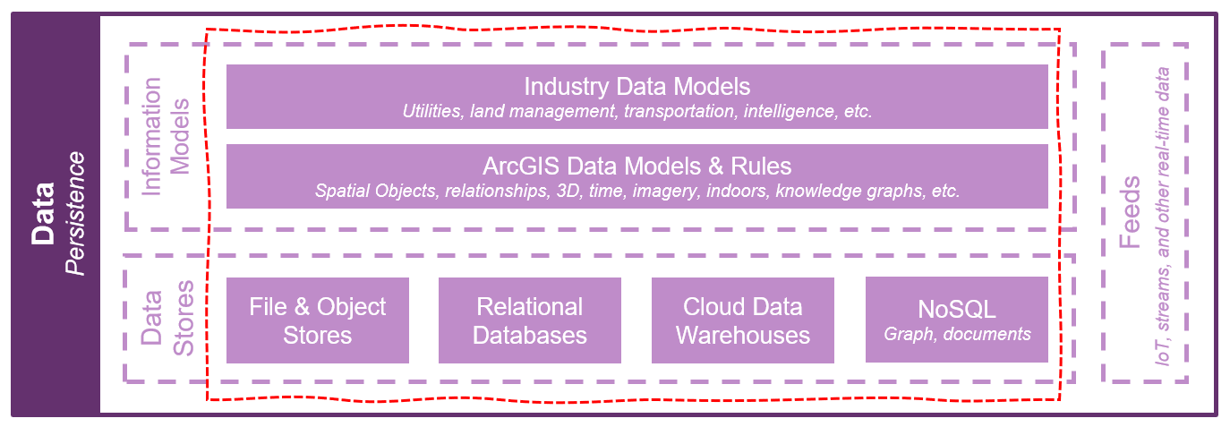
Self-service mapping, analysis, and sharing systems work with just about every type of data and data store supported by ArcGIS, including file and object stores, databases, cloud data warehouses, and NoSQL stores. Data from these sources may not be managed in this system, but rather connected to this system for web access and use in mapping, analysis, and sharing workflows.
The ArcGIS data models and rules are employed to support rich mapping, visualization, and analysis capabilities. Industry-specific data models are also commonly used to enable industry-specific workflows through self-service applications, tools, and other configurations of ArcGIS.
Real-time and IoT feeds are not typically served or managed in self-service mapping, analysis, and sharing systems, though such feeds may be incorporated at the application tier for mapping, analysis, and sharing workflows. Learn more about real-time data streaming and analytics systems.
Services (logic)
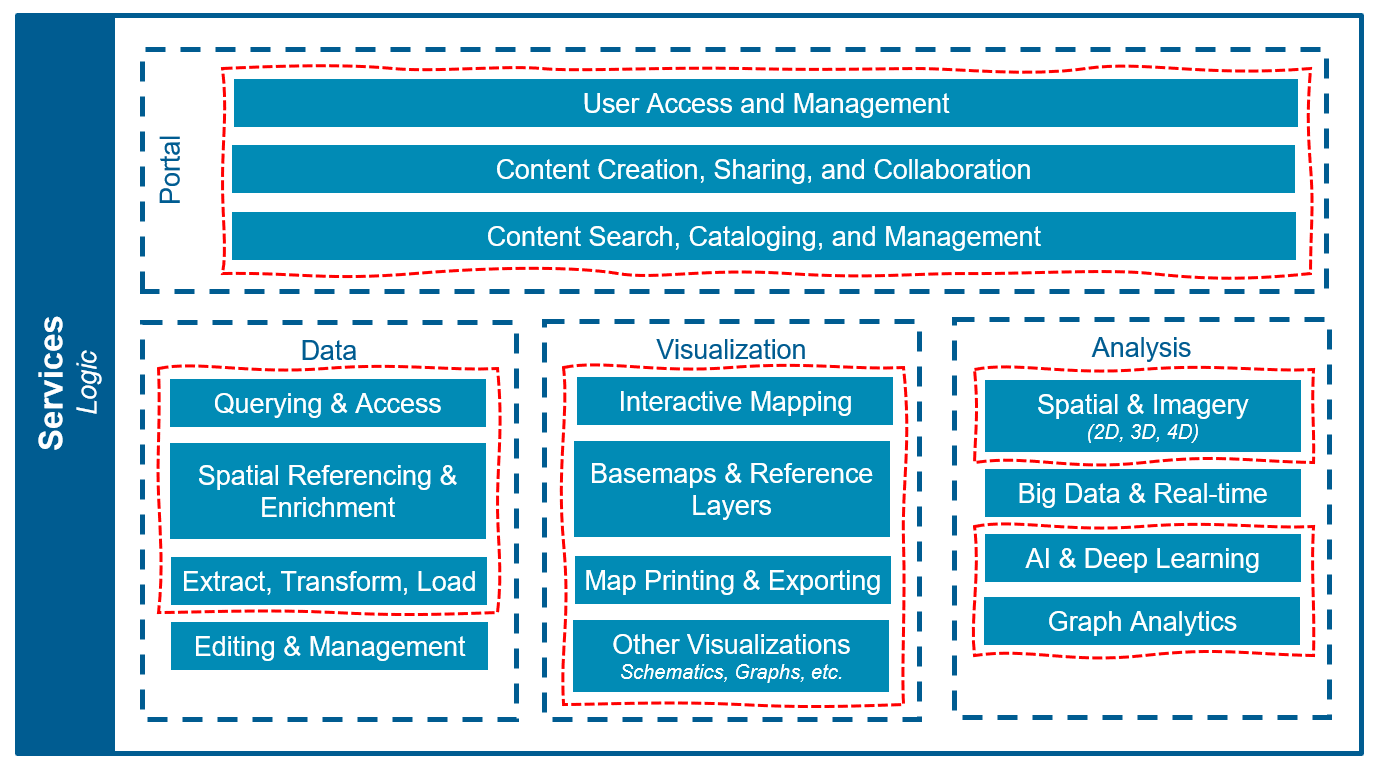
Self-service mapping, analysis, and sharing systems often enable a majority of services supported by ArcGIS. This includes full support for visualization services and a majority of data and analysis services. Exceptions include data editing and management, which while possible in this system are typically better addressed with a data editing and management system, as well as big data and real-time analytics, which services are more commonly provided by a big data analytics system and/or a real-time data streaming and analytics systems.
Some of the spatial analysis capabilities provided by self-service mapping, analysis, and sharing systems rely on location services provided by a location services system. These include, but are not limited to, network analysis and GeoEnrichment services, which can be integrated into the self-service mapping, analysis, and sharing system as utility services.
Self-service mapping, analysis, and sharing systems make heavy use of portal services to deliver their self-service and sharing capabilities, including robust support for user access and management, as well as content creation, sharing, collaboration, search, cataloging, and management.
The ArcGIS REST API is used as the main endpoint into the system for application access, though some applications may leverage other services-based APIs.
Applications (presentation)

Self-service mapping, analysis, and sharing systems leverage the full suite of applications, app builders, and mapping SDKs provided by Esri, enabling an astoundingly wide variety of geospatial workflows across an organization, and delivering suitable apps to just about every type of user.
For more information see the applications section above.
Support
Self-service mapping, analysis, and sharing systems support a broad spectrum of users and workflows across an organization’s enterprise; however, these workflows tend not to be mission critical. As such, availability SLAs and other reliability requirements are often less aggressive with this system than with some other ArcGIS systems.
Security, performance, and scalability all require careful consideration in this system, given the potential broad access and use it can provide. Organizations should review and consider organization-level business and IT guidance around security and data sharing and implement data and application-level security protocols within the system as appropriate.
Observability is especially important with this system pattern. The flexible, self-service use of this system benefits greatly from governance, which is best implemented through awareness of evolving usage patterns and practices learned through observation. Organizations getting started with this system pattern are strongly encouraged to introduce governance and change management policies early. Additionally, ongoing review and housekeeping of content, groups, and users is strongly recommended, and can be enabled in large part through automation.
The self-service nature of content creation with this system pattern may demand unique environment isolation and change management considerations.
Integration with other systems is common, including the incorporation of external data and services into this system for self-service mapping and analysis workflows, as well as the sharing of maps and other content from this system with other systems across the enterprise.
For general support and architecture considerations please see architecture practices as well as the architecture pillars of the ArcGIS Well-Architected Framework.
Related system patterns
Self-service mapping, analysis, and sharing systems are foundational to most organizational use of GIS. As such, this system is commonly integrated with other ArcGIS systems or (in some cases) combined with other ArcGIS system patterns. Some common examples include:
- Combining with a location services system pattern to create an all-purpose, starter GIS system complete with applications, data hosting, and sharing capabilities.
- Integrating with an enterprise application hosting and management system to support promoting applications and content created in this system for delivery with higher SLAs to the enterprise.
- Leveraging this system as the means of disseminating content created and/or managed in another system to the enterprise. Other such systems may include, but are not limited to, data editing and management systems, imagery data management and analytics systems, and big data analytics systems.
For more information on integrating or composing system patterns, please see using system patterns
Examples
Industry-specific system examples for this system pattern include:
- Commercial. Organizations in commercial real estate, financial services, and retail sectors can utilize a Self-Service Mapping, Analysis, and Sharing system pattern to enable users to create their own map and application information products to be shared internally with stakeholders, other GIS Professionals and decision makers. Commercial organizations use Self Service Mapping, Analysis, and Sharing to make business decisions, innovate and take advantage of spatially aware business intelligence tools. See JLL as an example of self-service mapping.
- Health and human services. GIS professionals and researchers in health care and public health organizations can utilize a Self-Service Mapping, Analysis, and Sharing system pattern to take advantage of authoritative geospatial data and create information products exploring research questions. Health and Human Services organizations can allow their GIS teams to create dashboards, StoryMaps, and applications related to public health preparedness efforts and equity of service offerings. They may also allow users to create maps and apps internally using sensitive data and share resultant findings publicly to inform policy and decision making. Kansas Overdose Response Strategy Team was able to identify overdose hot spots and prioritize locations for mentorship programs for at-risk youth.
- Insurance. Insurers use spatial data to help manage risk and appropriately price their insurance policies. They utilize a Self-Service Mapping, Analysis, and Sharing System Pattern to map risk and support damage assessments. GIS Professionals and data analysts can create applications including claims data, strategic approaches and resilience plans and share them internally for stakeholders and leadership or publicly to increase support awareness for customers. Insurance organizations may take advantage of spatially aware business intelligence tools and share analysis outputs with decision makers.
- National government. National agencies often collect extremely large troves of data about social, economic, and environmental activity. Using a Self-Service Mapping, Analysis, and Sharing system pattern, they can encourage users to create new applications aimed at supporting agriculture services, aviation, defense, and intelligence. These services can be a combination of Location Services like land use combined with authoritative content such as national park boundaries or active fire maps. National Government GIS Professionals can gather insights into lending programs, public health information, fire maps and elections. The Republic of Colombia’s IGAC wanted to create the first public-facing national tool to access geographic data.
- Natural resources. With a Self-Service Mapping, Analysis, and Sharing system pattern, oil and gas companies can enable users to use a shared data repository to create applications in support of drilling and extraction plans. Their users can create maps that streamline daily workflows and improve upon existing workflows. Natural Resources users might also create applications, StoryMaps, Workflow Management Processes, and dashboards in service of energy and regulation managers, users, and stakeholders. Natural resource organizations might also serve analysis outcomes to the public, such as planning and assessment content and suitability analysis. Natural Resource GIS Professionals might access Living Atlas Location Services in combination with proprietary data, like wind farms, to create impact analysis maps aimed at informing the public and securing financing for projects.
- State and local government. State and local agencies rely on data to help provide effective services to citizens and employees. With a Self-Service Mapping, Analysis, and Sharing system pattern, they can enable GIS professionals and data analysts to access authoritative data libraries and combine data in applications to serve their communities with agility. A Self Service Mapping, Analysis, and Sharing Pattern has the potential to serve GIS users from a variety of agencies and departments including airports, elections, emergency management, fire rescue, public safety and more. Each of these agencies benefits from Dashboards, StoryMaps and Experience Builder applications as well as integration with Third Party Vendors. Further, Esri’s ArcGIS Solutions offer ready-made applications aimed at improving the efficiencies for many daily tasks. These solutions are often low code or no code and allow users to get up and running very quickly. Some examples of state and local government support include, standing up self service Election Mapping and Way finding, housing and homelessness services and urban and community planning content. This pattern is ideal for an organizations like law enforcement agencies that do not need to share content externally but can take advantage of internet enabled rest services like imagery and basemaps. Las Cruces, New Mexico is enabling departments to address their own issues with self-service mapping.
- Telecommunications. With a Self-Service Mapping, Analysis, and Sharing system pattern, telecommunications companies can allow their GIS teams to create applications that inform decision making by expanding on location intelligence and enable users to take advantage of internal location services, including proprietary mapping and customer data, paired with boundary and analysis layers to show impact and accessibility statistics for users. The organization can use authoritative data such as access maps and workforce distribution to share outage response times with users and the community. Further, telecommunications organizations can use Esri Solutions, Dashboards and Experience Builder applications to take advantage of location analytics around networks, operations, maintenance, sales, planning and customer services. CTDOT helps users access past assets and current project data via self-service mapping.
- Utilities. Utilities can use a Self-Service Mapping, Analysis, and Sharing system pattern to create maps and applications that inform the system of engagement for users and professionals as well as specialized tools for data management and modeling. These applications combine authoritative data layers aimed at asset management, operational management, safety, compliance, and customer services with Location Services, Imagery, Basemaps and Analysis tools. GIS Professionals create maps and applications to aid with grid modernization, emergency response and field operations. The Self-Service Mapping, Analysis, and Sharing Pattern provides unique capabilities to support advanced data management and modeling. For example, they can use the Parcel Fabric or Utility Network data models to support industry-specific workflows like parcel management and network tracing.